images
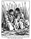
A cartoon of 2 soldiers sitting in wet tall grass. "Joe yestiddy you saved my life an' I swore I'd pay you back. Here's my last pair of dry socks."
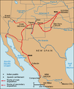
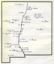
A map showing the path taken by Francisco Vasquez de Coronado in North America.
A black and white photo of a soldier standing next to an armored vehicle with the text, "an armored motor car for attacking aero planes."
A black and white photo of people standing around an old airplane with writing on the bottom that says "U.S. Army airplane arriving at a village in Mexico."
A photo of Pancho Villa riding with a large group of men that has the writing "Pancho in his fighting clothes."
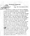
A telegram from London to Mexico stating that they plan on using submarine warfare, and inviting Mexico to ally with them when war starts with the U.S., and to take parts of the United States back. The telegram also asks the receiver to notify the president of all of this.


